

| Rivers, lakes & canals 12 Nov 2020 - Elliott Brown |
Gallery |
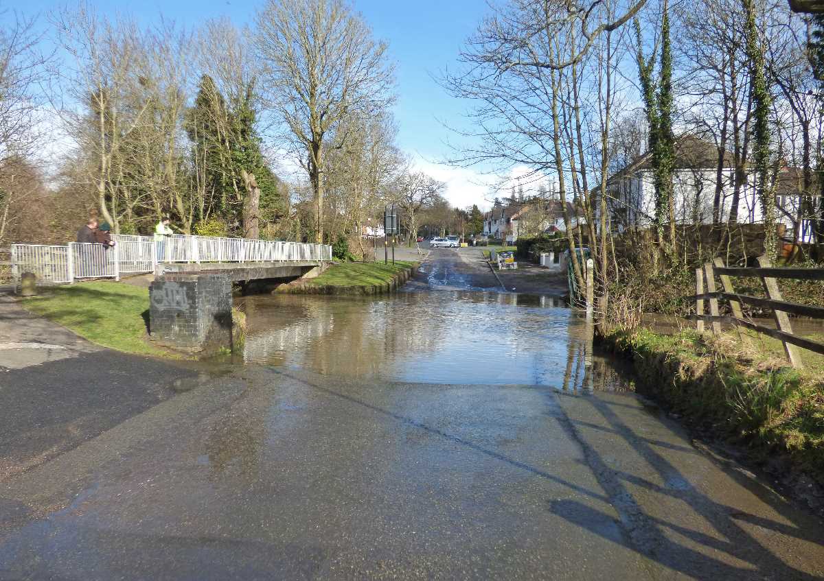
The River Cole at the Scribers Lane ford
 (1).jpg?v=1)
There is a few fords that pass through the River Cole. Scribers Lane in Hall Green near Yardley Wood is one of them. Located in the Shire Country Park between the Trittiford Mill Pool and the Scribers Lane SINC. This road is no longer in use, as there is bollards at both ends. There is a footbridge for pedestrians, cyclists and dog walkers. The river level changes here during the year.
The River Cole at the Scribers Lane ford
 (1).jpg)
There is a few fords that pass through the River Cole. Scribers Lane in Hall Green near Yardley Wood is one of them. Located in the Shire Country Park between the Trittiford Mill Pool and the Scribers Lane SINC. This road is no longer in use, as there is bollards at both ends. There is a footbridge for pedestrians, cyclists and dog walkers. The river level changes here during the year.
River Cole at the Scribers Lane ford
This ford is located on Scribers Lane between Yardley Wood and Hall Green in Birmingham. The River Cole flows through the road on the Cole Valley. Nearby is the Trittiford Mill Pool and the Scribers Lane SINC. Visitors on walks can use a footbridge to cross the river on Scribers Lane. There is bollards at both ends of the river, as it is no longer suitable for cars or other motor vehicles to cross over. One set of bollards on Scribers Lane is near Riverside Crescent. Pedestrians can walk through the middle in the gap.
For my Shire Country Park posts relevant to this area:
2014-16
After a walk down to The Baldwin during February 2014, I walked down Baldwins Lane and then onto Scribers Lane. I got to this Ford sign just before the railway bridge on the Shakespeare Line.
dndimg alt="Scribers Lane Ford" dndsrc="../uploadedfiles/Scribers Lane ford SCP (Feb 2014) (1).JPG" style="width: 100%;" />
The road is liable to flooding. Only cycles can go past here. At the time I thought that you couldn't walk up the road, so I turned back. Beyond here is the Scribers Lane Allotments.
dndimg alt="Scribers Lane Ford" dndsrc="../uploadedfiles/Scribers Lane ford SCP (Feb 2014) (2).JPG" style="width: 100%;" />
The May Day Bank Holiday during May 2016. After leaving the Trittiford Mill Pool, saw the River Cole on the Scribers Lane ford for the first time.
The back of the tree near the River Cole. From a footbridge at the far end of the Trittiford Mill Pool. Can just about see the road surface to the right.
dndimg alt="Scribers Lane ford" dndsrc="../uploadedfiles/Trittiford Mill Pool SCP (May 2016) (12).jpg" style="width: 100%;" />
There's the bridge that pedestrians and cyclists can use to cross the river.
dndimg alt="Scribers Lane Ford" dndsrc="../uploadedfiles/Scribers Lane ford SCP (May 2016) (1).jpg" style="width: 100%;" />
At this point in the Spring, the river level was quite low.
dndimg alt="Scribers Lane Ford" dndsrc="../uploadedfiles/Scribers Lane ford SCP (May 2016) (2).jpg" style="width: 100%;" />
Scribers Lane sign near the bridge.
dndimg alt="Scribers Lane Ford" dndsrc="../uploadedfiles/Scribers Lane ford SCP (May 2016) (3).jpg" style="width: 100%;" />
Discarded barrier in the River Cole near the Scribers Lane ford.
dndimg alt="Scribers Lane Ford" dndsrc="../uploadedfiles/Scribers Lane ford SCP (May 2016) (4).jpg" style="width: 100%;" />
The other side of the River Cole into the Scribers Lane SINC.
dndimg alt="Scribers Lane Ford" dndsrc="../uploadedfiles/Scribers Lane ford SCP (May 2016) (5).jpg" style="width: 100%;" />
These views of the River Cole at the Scribers Lane ford taken during December 2016. The river level is always higher in late autumn and early winter. This was after a period of heavy rain.
dndimg alt="Scribers Lane Ford" dndsrc="../uploadedfiles/Trittiford Mill Pool SCP (Dec 2016) (5).jpg" style="width: 100%;" />
You can see why this road is closed off to cars or other motor vehicles, it is just too unsafe for them to pass without them getting stuck.
dndimg alt="Scribers Lane Ford" dndsrc="../uploadedfiles/Trittiford Mill Pool SCP (Dec 2016) (6).jpg" style="width: 100%;" />
2020
The first National Lockdown at the end of March 2020, and a walk down Scribers Lane to get onto the Trittiford Mill Pool. First up the railway bridge on the Shakespeare Line between Yardley Wood and Shirley.
dndimg alt="Scribers Lane Ford" dndsrc="../uploadedfiles/Scribers Lane ford SCP (March 2020) (1).jpg" style="width: 100%;" />
It seems that you can walk down Scribers Lane. Trees yet to get their leaves grown back.
dndimg alt="Scribers Lane Ford" dndsrc="../uploadedfiles/Scribers Lane ford SCP (March 2020) (2).jpg" style="width: 100%;" />
Bollards just before the footbridge. The River Cole is to the right on Scribers Lane.
dndimg alt="Scribers Lane Ford" dndsrc="../uploadedfiles/Scribers Lane ford SCP (March 2020) (3).jpg" style="width: 100%;" />
Crossing the footbridge over the River Cole.
dndimg alt="Scribers Lane Ford" dndsrc="../uploadedfiles/Scribers Lane ford SCP (March 2020) (4).jpg" style="width: 100%;" />
The view of the River Cole from the footbridge on Scribers Lane.
dndimg alt="Scribers Lane Ford" dndsrc="../uploadedfiles/Scribers Lane ford SCP (March 2020) (5).jpg" style="width: 100%;" />
The River Cole from the other side. Within months all of the natural growth would grow back during the first lockdown.
dndimg alt="Scribers Lane Ford" dndsrc="../uploadedfiles/Scribers Lane ford SCP (March 2020) (6).jpg" style="width: 100%;" />
The River Cole looked shallow enough to go into from Scribers Lane.
dndimg alt="Scribers Lane Ford" dndsrc="../uploadedfiles/Scribers Lane ford SCP (March 2020) (7).jpg" style="width: 100%;" />
The main tree near the River Cole on Scribers Lane. Water surrounds it when the river level is higher.
dndimg alt="Scribers Lane Ford" dndsrc="../uploadedfiles/Scribers Lane ford SCP (March 2020) (8).jpg" style="width: 100%;" />
Still in lockdown during May 2020. The trees are now lush and green. A month long drought, and the River Cole was quite shallow.
dndimg alt="Scribers Lane Ford" dndsrc="../uploadedfiles/Scribers Lane ford SCP (May 2020) (1).jpg" style="width: 100%;" />
Even the main tree was looking dry as the leaves were green, and the river was low.
dndimg alt="Scribers Lane Ford" dndsrc="../uploadedfiles/Scribers Lane ford SCP (May 2020) (2).jpg" style="width: 100%;" />
It was so nice and warm in May, and the Shire Country Park was looking green near the River Cole on Scribers Lane.
dndimg alt="Scribers Lane Ford" dndsrc="../uploadedfiles/Scribers Lane ford SCP (May 2020) (3).jpg" style="width: 100%;" />
The 2nd lockdown began on the 5th November 2020. After a walk down to Yardley Wood and into the Trittiford Mill Pool. Got some Autumnal views of the River Cole on Scribers Lane. The river level now looks higher.
dndimg alt="Scribers Lane Ford" dndsrc="../uploadedfiles/Scribers Lane Ford SCP (Nov 2020) (1).jpg" style="width: 100%;" />
There's that tree again, the River Cole going behind it, but the land around it was not flooded at this point.
dndimg alt="Scribers Lane Ford" dndsrc="../uploadedfiles/Scribers Lane Ford SCP (Nov 2020) (2).jpg" style="width: 100%;" />
Heading to the footbridge over the River Cole. The closest cars can get now is behind the bollards and close to the Allotments.
dndimg alt="Scribers Lane Ford" dndsrc="../uploadedfiles/Scribers Lane Ford SCP (Nov 2020) (3).jpg" style="width: 100%;" />
I think the river level is too high for cyclists to ride through. Then again, I expect that they use the bridge as it's safer to cross.
dndimg alt="Scribers Lane Ford" dndsrc="../uploadedfiles/Scribers Lane Ford SCP (Nov 2020) (4).jpg" style="width: 100%;" />
The walk up Scribers Lane towards the railway bridge. Vehicles that do drive down here must be under 12'6".
dndimg alt="Scribers Lane Ford" dndsrc="../uploadedfiles/Scribers Lane Ford SCP (Nov 2020) (5).jpg" style="width: 100%;" />
There is also the ford on Slade Lane. I think I'll do a separate post on that ford at a later date.
The other ford in the Shire Country Park, but one that cars can drive through is on Green Road near the Greet Mill Meadow and Sarehole Mill Recreation Ground.
Photos taken by Elliott Brown. Can be found on Twitter: ellrbrown.
 (3).jpg?v=1)
 (3).jpg)
 (5).jpg?v=1)
 (5).jpg)
 (5).jpg?v=1)
 (5).jpg)
 (7).jpg?v=1)
 (7).jpg)
 (6).jpg?v=1)
 (6).jpg)
 (8).jpg?v=1)
 (8).jpg)
 (6).jpg?v=1)
 (6).jpg)
 (4).jpg?v=1)
 (4).jpg)
 (8).jpg?v=1)
 (8).jpg)
 (11).jpg?v=1)
 (11).jpg)